Red Slide Park
389 Lang Street, Haw River, NC 27258
…to…
Graham Paddle Access
1124 Cooper Road, Graham, NC 27253

…to…
Swepsonville River Park (Upper Access)
2472 Boywood Road, Swepsonville, NC 27253
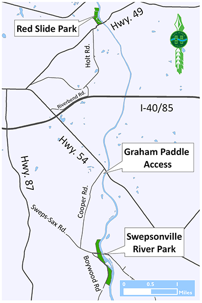
Graham Paddle Access to Swepsonville River Park:
Distance: 2.25 miles/1.5 hours
Difficulty: Beginner
Minimum USGS Gauge Level: 1.7 ft at Haw River
Red Slide Park to Graham Paddle Access:
Distance: 3.5 miles/2.0 hours
Difficulty: Beginner
Minimum USGS Gauge Level: 1.7 ft at Haw River
First impressions aren’t always accurate, as you’ll quickly discover on the 3.5-mile stretch of the Haw between Red Slide Park and Graham Paddle Access.
From Red Slide Park in Haw River you’ll likely think you’re in for a rollercoaster of a paddle. And you are — for the first 50 yards or so. After putting in, you have about 20 yards to figure out how to attack a frisky Class I-II set of rapids that drops three feet within 30 feet: the result of a dam, now decommissioned, that once helped power the old Granite Cotton Mill just across the river (which once produced 10 percent of all cloth made in the United States). That the mill located here was no fluke; Red Slide Park occupies what was once, dating back to the 1700s, the most popular ford along the Haw- Piney Ford.
The banks along this stretch of the Haw are high, about 20 feet for the most part. Giant sycamore, their gnarled, exposed roots clinging to the eroding banks, lean over the river offering much appreciated shade on a summer paddle. There are occasional sights to see: the USGS gauge is a mile in; a rock ledge a half mile beyond that suggesting the foundation of a long-abandoned roadbed; and chairs set up on a bluff at mile 2.8 that are not there for the purpose of watching your paddling prowess, but rather for taking in the spectacular sunsets. As you pass beneath the Interstate 40/85 bridge, note the branches and debris wedged in the catwalk above and contemplate a Haw about 25 feet higher than what you’re paddling.
Graham Paddle Access, river right, comes upon you quickly after you pass under the NC 54 bridge. Be prepared. If you like the idea of paddling whitewater but lack the experience to confidently navigate it, the stretch between NC 54 and Swepsonville is a good place to practice.
Just below the put-in is a quick riffle. Less than a half mile down you’ll encounter a pair of Class I rapids spaced about 40 yards apart. The first serves as a wake-up, the second is a slightly bigger drop (though nothing to be concerned about). Paddle another half mile and you’ll hit another pair of Class I’s, these spaced about 25 yards apart. Another Class I awaits just above the Swepsonville-Saxapahaw Road bridge.
The take-out is just before the old dam remnant, river right. For those looking to continue downstream, portage is available on river right.


Red Slide Park
389 Lang Street, Haw River, NC 27258
…to…
Graham Paddle Access
1124 Cooper Road, Graham, NC 27253
…to…
Swepsonville River Park (Upper Access)
2472 Boywood Road, Swepsonville, NC 27253
Graham Paddle Access to Swepsonville River Park:
Distance: 2.25 miles/1.5 hours
Difficulty: Beginner
Minimum USGS Gauge Level: 1.7 ft at Haw River
Red Slide Park to Graham Paddle Access:
Distance: 3.5 miles/2.0 hours
Difficulty: Beginner
Minimum USGS Gauge Level: 1.7 ft at Haw River
First impressions aren’t always accurate, as you’ll quickly discover on the 3.5-mile stretch of the Haw between Red Slide Park and Graham Paddle Access.
From Red Slide Park in Haw River you’ll likely think you’re in for a rollercoaster of a paddle. And you are — for the first 50 yards or so. After putting in, you have about 20 yards to figure out how to attack a frisky Class I-II set of rapids that drops three feet within 30 feet: the result of a dam, now decommissioned, that once helped power the old Granite Cotton Mill just across the river (which once produced 10 percent of all cloth made in the United States). That the mill located here was no fluke; Red Slide Park occupies what was once, dating back to the 1700s, the most popular ford along the Haw- Piney Ford.
The banks along this stretch of the Haw are high, about 20 feet for the most part. Giant sycamore, their gnarled, exposed roots clinging to the eroding banks, lean over the river offering much appreciated shade on a summer paddle. There are occasional sights to see: the USGS gauge is a mile in; a rock ledge a half mile beyond that suggesting the foundation of a long-abandoned roadbed; and chairs set up on a bluff at mile 2.8 that are not there for the purpose of watching your paddling prowess, but rather for taking in the spectacular sunsets. As you pass beneath the Interstate 40/85 bridge, note the branches and debris wedged in the catwalk above and contemplate a Haw about 25 feet higher than what you’re paddling.
Graham Paddle Access, river right, comes upon you quickly after you pass under the NC 54 bridge. Be prepared. If you like the idea of paddling whitewater but lack the experience to confidently navigate it, the stretch between NC 54 and Swepsonville is a good place to practice.
Just below the put-in is a quick riffle. Less than a half mile down you’ll encounter a pair of Class I rapids spaced about 40 yards apart. The first serves as a wake-up, the second is a slightly bigger drop (though nothing to be concerned about). Paddle another half mile and you’ll hit another pair of Class I’s, these spaced about 25 yards apart. Another Class I awaits just above the Swepsonville-Saxapahaw Road bridge.
The take-out is just before the old dam remnant, river right. For those looking to continue downstream, portage is available on river right.